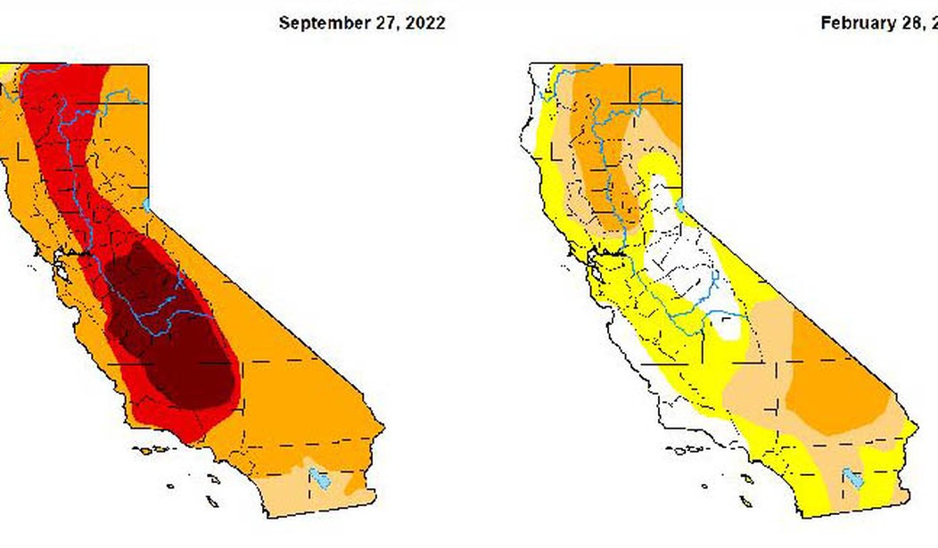
The San Francisco Chronicle calls it a “stunning improvement” and that’s pretty accurate. As of last September, the California drought monitor estimated that 99.76% of the state was experiencing some level of drought (moderate, severe, extreme or exceptional). As of yesterday, that figure has dropped to 49 percent. And the situation is even better than that sounds because no part of California remains in the worst two categories.
Just last week, 85% of the state had been in drought. And three months ago, the entire state was in drought, with 40% of California experiencing extreme or exceptional drought. None of the state remains in those two dire categories, though a quarter of California — especially the northeast quadrant — remains in severe drought, according to the map.
“It’s the first time since summer 2020 that less than half the state has been in drought and less than a quarter in severe or worse conditions,” tweeted the National Drought Mitigation Center at the University of Nebraska-Lincoln. It’s the group that draws the maps, together with the Department of Agriculture and the National Oceanic and Atmospheric Administration.
Of course it hasn’t always been an easy road. In January many parts of the state experienced serious flooding. And the whole state got hit again over the last week or two with lots more rain and snow. Where I live in Orange County it was mostly rain though we also had a weird variety of hail called graupel which is like mini-snowballs. That only lasted about 2 minutes but it’s something you don’t see very often.
.@kcalnews Hail in #Huntington Beach! Big, large and brrrrr COLD hail! pic.twitter.com/iY1Vkugo2Q
— Janice (@thischickthat) March 1, 2023
In some place that rain (and hail) came down as snow. In fact, there was a snow sighting near the famous Hollywood sign in LA which made local and international news.
Snow at the Hollywood sign! (Video: KNBC) pic.twitter.com/vRLTxWvoLf
— Mike Sington (@MikeSington) February 24, 2023
It’s a rare and pretty sight.
Check out this sight from Culver City of the Hollywood sign and snow capped mountains behind it! 😍🗻❄️
📸: Ross Kestin pic.twitter.com/uiQWFdDx3c
— ABC7 Eyewitness News (@ABC7) February 27, 2023
As a result of all of this, the snowpack in the mountains is way above average.
California’s snowpack is approaching record levels last set in the 1982-83 snow year after weeks of storms this season, state officials said on Friday.
The Department of Water Resources’ electronic readings from 130 snow sensors across the state found the snowpack’s snow water equivalent is 44.7 inches or 190% of the average for the date.
That’s good news because that’s where we get our water during the summer when there isn’t much rain but the snow melts. The snowpack is expected to peak about a month from now so it’s still growing. Meanwhile, some folks are dealing with a real problem just trying to leave the house.
Mammoth Lakes California. A friend sent this. 10 feet of snow. But don’t worry California will remain in a drought due to lack of water storage. pic.twitter.com/VuBh86k7Yt
— Lori Mills (@LoriMills4CA42) February 27, 2023
California’s biggest reservoirs are also looking better. Three of the eight largest are now at or above average levels for this time of year.
Each of the state’s eight largest reservoirs — those with over 1 million acre-feet in capacity — has seen its water level steadily rise since December. While three of these major reservoirs, Oroville, Don Pedro and McClure, have surpassed their historical average water storage level for this time of year, the others have not.
Trinity Lake, the third largest reservoir in the state, remains at 48% of historical average, according to data as of March 1 from the Department of Water Resources…
Lake Sonoma near Cloverdale has surpassed its historic average for this time of year, while last year it was only at 62%. Lake Berryessa, one of the eight largest reservoirs in the state, is also up — it’s at 83% of its historic average, compared with 78% at this time last year.
According to this meteorologist, there’s still more rain and snow to come in the next couple weeks.
The drought in California is closer to being completely [officially] over. The drought monitor updates every Thursday.
Pattern favors boatloads more rain and snow over California and West Coast over next 1-2 weeks.
More juicy atmospheric rivers 🌧📈https://t.co/6I1YBEcOKf pic.twitter.com/kVjPzdGMhh
— Ryan Maue (@RyanMaue) March 2, 2023
The drought monitor maps get updated every Thursday so hopefully by this time next week we’ll have evidence of further improvement.


Join the conversation as a VIP Member