We’ve had a lot of rain here in California over the past two weeks but it’s about to get much more severe. Something called a “bomb cyclone” with a core that is about 400 miles across is hitting the coast today. Estimates predict some areas could see as much as 1″ of rain in an hour. Here’s video of this cyclone moving in:
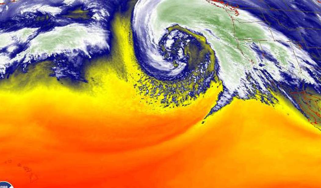
The bomb-cyclone system continues to strengthen as it spins off the coast of California and Oregon, leaving a spectacular display on satellite imagery as it undergoes its rapid intensification.
Read more: https://t.co/nwT8c7JhL2 pic.twitter.com/FZ8jqLisaV
— San Francisco Chronicle (@sfchronicle) January 4, 2023
From the Chronicle:
Yet another winter storm is set to pummel California today with strong winds and heavy rainfall. Forecasts for the storm have been dire, prompting cities in the Bay Area to frantically prepare emergency services, and issue strong warnings to avoid traveling if possible. A National Weather Service forecast said the impacts will include “widespread flooding, roads washing out, hillside collapsing, trees down, widespread power outages, immediate disruption to commerce, and the worst of all, likely loss of human life.”
Weather models expect the first wave of strong winds and rain to roll in this morning, bringing 35 to 45 mph gusts to large swaths of the Peninsula, North Bay and Santa Cruz Mountains, along with rainfall rates at around a quarter of an inch per hour until noon. The strong winds are expected to drop off Wednesday night, but heavy downpours will persist across most of the Bay Area through Thursday morning.
The National Weather Service put out this graphic showing when the heavy rains are expected to arrive.
We know you're waiting on the heavier rain. It's coming. Here are approximate arrival times for the heavier rain band. Expect flooding concerns to increase later this afternoon into tonight across the area. Stay safe! #cawx pic.twitter.com/11brmjqaD3
— NWS Bay Area 🌉 (@NWSBayArea) January 4, 2023
Alameda County is encouraging some residents to evacuate now because it’s possible emergency vehicles won’t be able to get to them and people who remain may not be able to leave for several days. Residents in Santa Cruz county are also being warned about a possible culvert failure which could cut off roads. And of course San Francisco is right in the path of the storm:
The National Weather Service’s Bay Area office issued a frank and dire warning to citizens in a statement, saying the storm, which is currently forecast to begin peaking Tuesday night and Wednesday morning, could bring about flooding and the loss of life.
“To put it simply, this will likely be one of the most impactful systems on a widespread scale that this meteorologist has seen in a long while,” the warning read. “The impacts will include widespread flooding, roads washing out, hillside collapsing, trees down (potentially full groves), widespread power outages, immediate disruption to commerce, and the worst of all, likely loss of human life. This is truly a brutal system that we are looking at and needs to be taken seriously.”
Northern California is going to get the worst of this but because of the size of this storm, southern California won’t be spared either.
Los Angeles County has already issued evacuation warnings for residents in two northern mountainous communities close to perilous burn scars, and officials in Orange County are still working to remedy a landslide from earlier storms — with more rainfall predicted soon. Gov. Gavin Newsom on Wednesday proclaimed a statewide emergency to “support response and recovery efforts” across the already-saturated state…
Karla Nemeth, director of the California Department of Water Resources, said flooding and heavy rainfall are major concerns, but called high winds the “signature” of this storm.
“This is an extreme weather event; we’re moving from extreme drought to extreme flood,” Nemeth said. “What that means is a lot of our trees are stressed after three years of intensive drought, the ground is saturated and there is a significant chance of downed trees that will create significant problems, potentially flooding problems, potentially power problems.”…
“Even in the lower elevations, we’ll be looking at wind gusts at 40 to 50 mph, very strong winds,” [meteorologist David] Sweet said, which means possible power outages, downed trees and other debris concerns.
This next map shows some of the current wave heights at different spots in the storm (2nd graphic below). The maximum height near the center is 45 feet.
The latest significant wave height analysis maintains a 45 ft max sw of the low center where hurricane force winds are located. The small red numbers on the bottom right of the surface plots are seas from ship and buoys – i.e., buoy 46006 (41N138W) was 18 ft at 18z. #MarineWx pic.twitter.com/ddpECSLmrs
— NWS OPC (@NWSOPC) January 4, 2023
From SF Gate:
The bomb cyclone pushing toward Northern California is creating 45-foot-tall waves in the Pacific Ocean. The latest imagery from the National Weather Service Ocean Prediction Center shows 45-foot waves in the center of the storm, with “hurricane force winds” accompanying the churning seas…
By the time it reaches shore later this afternoon, forecasters think waves up to 30 feet tall may occur along the the California coast.
I hope a bunch of amateur surfers aren’t at the beach right now waiting for this thing. Anyway, this could be a real mess statewide for a lot of people as trees take out power lines and over-saturated ground gives way to mudslides.


Join the conversation as a VIP Member